Copied!
Back to back chevron-left-dark

Landscape Development, Signage, and Interpretation

The unique landscapes of the Zippori Stream, its forests, and the surrounding open spaces have always drawn many visitors – both local residents and travelers from afar. Landscape development aims to create a clear identity for the stream environment and to strengthen the connection between the stream and nearby communities through various design elements. As part of the Zippori Stream restoration project, a unified, basin-wide design language was developed – the first of its kind in Israel. This design language is reflected in trails, seating areas, bridges, and other elements. It helps tell a cohesive “basin story” that is also embodied in a continuous walking path stretching along most of the stream, with side trails branching off to connect nearby communities and offer them easy and direct access to the stream.

Since the Zippori Stream area is an open space with free access along its entire length, landscape planning must take this into account. The project emphasizes accessibility in several sections of the stream for people with special needs. Design elements created in collaboration with local communities were placed near parking entrances and along the paths, offering visitors a glimpse into the diverse populations living within the stream basin.

Signage along the walking paths shares information about the area’s ecology, history, and communities, as well as about the restoration activities themselves, many of which are not immediately visible. Directional signs were also added to guide visitors along various hiking routes.

All landscape development and interpretive elements are planned with careful attention to balancing public access with conservation of natural and scenic values and the stream’s unique character. Infrastructure is built to blend into the natural environment, with a long-term vision of sustainable development and preservation.

single-news-banner-image

What are the main goals in this area?

  1. Developing a unified basin-wide design language – This design language will establish shared planning principles for all stakeholders involved in landscape development throughout the stream basin.
  2. Creating a leisure and recreation network – Designed to provide visitors with a rich and meaningful experience, including diverse informational content.
  3. Developing entrance areas (trailheads) – Strategically placed to help distribute visitors throughout the area.
  4. Establishing a broad trail system – Planning a continuous streamside path from the upper basin to the lower basin, with connections to nearby communities, all designed in a consistent and cohesive style.
  5. Creating an accessibility system – Ensuring access to the stream area for people with special needs.
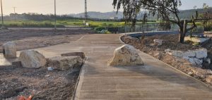
פיתוח נופי וחסימות לרכבים, עינות ציפורי בעין יבקע, קרדיט: ליגמ פרויקטים בע"מ
Landscape development and vehicle barriers, Zippori Springs at Ein Yivka Credit: Ligam Projects Ltd.

What are we actually doing? A few examples…
We’ve established entrance trailheads at key points along the stream, including parking, informational signage, and community-based elements. These trailheads help distribute visitors and reduce pressure on ecologically sensitive areas.
● We are creating accessible infrastructure for people with disabilities, including wheelchair-accessible paths from the trailheads to the stream, signage for the visually impaired, and audio guides embedded in “milestones” placed along the trails.
● We developed various interpretation tools along the stream, including playful and interactive signs, to promote understanding not only through reading but also through hands-on engagement.
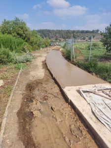
סלילת מקטע משביל הבטון (שביל הנחל) בעין יבקע, קרדיט: נחלת הכלל
Paving a section of the concrete trail (the Stream Trail) at Ein Yivka Credit: Public Domain

  • מועצה אזורית עמק יזרעאל
  • זבולון
  • ריינה
  • ביר אל מכסור
  • עילוט
  • לוגו רשות
  • קקל
  • קרן שטחים פתוחים

Did you know?